Core Platforms
A comprehensive intelligence ecosystem designed for zero failures in the most demanding environments on Earth.
Smart
Sensors
Built for the places other sensors simply give up.
When the network drops, when the dust settles in, when the temperature swings 40 degrees overnight — our sensors keep recording. No excuses, no gaps in the data.
Most monitoring systems weren't built for the places we work in. Underground mines, active dam faces, deep tunnels — these aren't server rooms. They're loud, wet, explosive-rated, and often completely cut off from any network signal. That's exactly where our sensors are designed to live. They don't need a stable connection to keep recording. They don't need a technician on-site to stay calibrated. Once they're in, they just work — through dust, flooding, pressure shifts, and years of continuous operation.
Always-On, Even Offline
Edge computing built right into the device means your data never stops — even when connectivity does. In remote mines and deep tunnels, that's not a feature. That's the whole point.
A Network That Heals Itself
Over 500 sensor nodes talk to each other over LoRaWAN mesh. If one drops out, the rest reroute automatically. Your monitoring stays intact without a single call to the field.
One Device, Every Signal
Strain. Vibration. Pressure. Convergence. Temperature. You're not buying five different sensors. It all comes from one rugged unit with a single unified data stream.
Certified for Where You Work
IP68-rated. ATEX-certified. Cleared for explosive atmospheres and submersion. 95% of our sensors are still active after 5 years in the field — without a single maintenance visit.
AI
Platform
It doesn't wait for something to go wrong. It sees it coming.
Most systems tell you what happened. Ours tells you what's about to happen — and gives you enough time to do something about it.
OctaSence's agentic AI layer continuously ingests sensor streams, refines its predictive models autonomously, and forecasts high-risk structural events — from pillar collapse to tailing dam seepage — hours or days before they occur, without any manual inspection. It watches everything, all the time. Not just flagging spikes, but actually learning the normal behaviour of your specific site — the way your dam wall moves after rainfall, the vibration signature of your tunnel during blasting, the slow creep of a slope that's been gradually shifting for weeks.
It Learns Your Site
Generic thresholds miss context. Our AI builds a behavioural baseline specific to your asset — your dam, your tunnel, your slope — and flags deviations a fixed rule would never catch.
48 Hours Ahead of Failure
On average, our early warning system surfaces critical risk signals 48 hours before a structural event. That window has already prevented evacuations, equipment losses, and worse.
No One Has to Be Watching
97% anomaly detection accuracy, running 24 hours a day, 7 days a week. The platform monitors continuously so your team can focus on decisions — not dashboards.
Reports That Write Themselves
Every alert and reading is automatically formatted into compliance-ready documentation. When the regulator asks, you're ready — without anyone staying late to compile a report.
Data
API
Your systems, your workflows — just with live structural intelligence flowing through them.
We built the API for teams who already have tools they trust. You shouldn't have to move into our platform to get value out of your sensor network.
The OctaSence Data API exposes raw sensor streams, processed analytics, and AI-generated risk scores via simple RESTful endpoints and low-latency WebSocket channels. It enables your engineering teams, SCADA systems, or third-party platforms to consume live structural intelligence directly — without changing how your team already works. Pull live readings from any sensor on any site. Get the AI risk scores alongside the raw numbers. Set up webhooks so your own systems get notified the moment an alert fires.
Real-Time Streams, No Compromise
WebSocket connections deliver live sensor data with sub-100ms latency. Whether you're feeding a SCADA system or a custom dashboard, the data arrives fast enough to actually matter.
Risk Scores Alongside Raw Numbers
Every API response includes the AI-generated risk score, not just the raw reading. You're not getting data — you're getting data with a verdict attached.
Instant Alerts, Your Way
Register a webhook and your own systems get notified the moment an alert fires. No polling, no delays — just an immediate signal straight to where your team already works.
Built for Developers, Trusted by Security
OpenAPI 3.0 spec. Python and JavaScript SDKs. OAuth 2.0 authentication. 99.9% uptime SLA. The kind of integration that passes a security review without a fight.

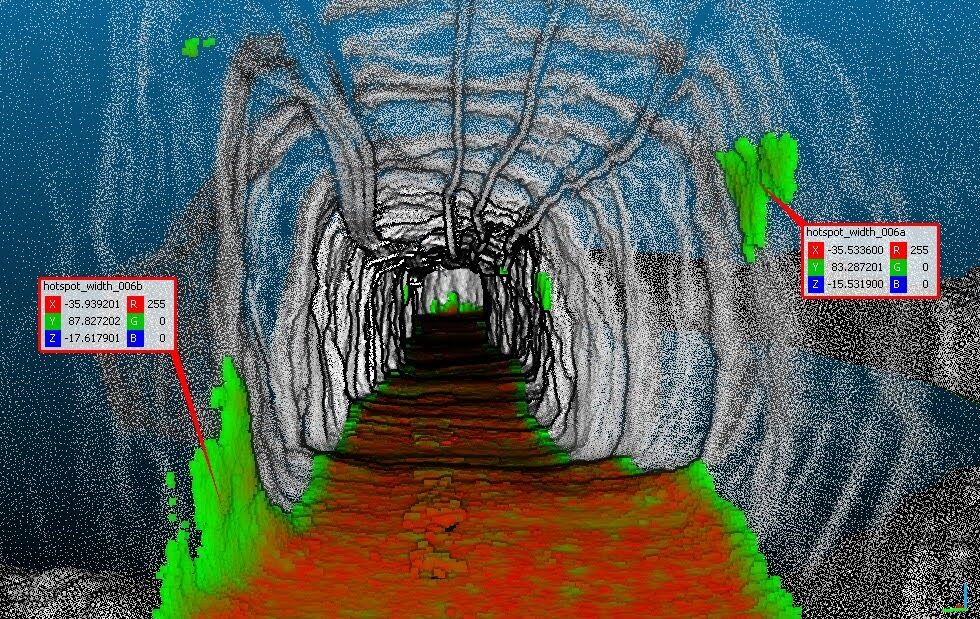
Digital
Twin
Not a model of what your asset looked like when it was built. A model of what it looks like right now.
Numbers in a spreadsheet tell you something changed. The digital twin shows you exactly where, exactly how much, and exactly where it's heading next.
Every asset we monitor gets a live 3D model — geo-referenced, layered with real subsurface data, and updated in real time from the sensor network. You can rotate it, zoom into any section, and see exactly where stress is building, where movement is happening, and how quickly things are changing. The heatmaps update every second. When a zone shifts from stable to amber, you see it immediately — not in a report the next morning. What makes it more than a visualisation is the simulation layer. You can run scenarios directly in the model — test loading conditions, failure progressions, and excavation plans before committing to anything in the real world.
A Living 3D Model, Every Second
Your asset geo-referenced, layered with real subsurface data, reflecting live sensor input — refreshing every single second. When a zone shifts to at-risk, you see it before it reaches your inbox.
Run the Scenario Before the Risk
What happens if you advance the tunnel face 20 metres? Test it in the twin first. Unlimited simulations, zero real-world consequences, complete audit trail of every scenario run.
Everyone Sees the Same Picture
A geotechnical engineer on-site and a risk director at head office can look at the same live model simultaneously — in a browser, no software to install, no version conflicts.
Heatmaps That Tell the Whole Story
Deformation zones, stress concentrations, risk layers — all colour-coded on the 3D model. 80% of structural risks our clients acted on were first spotted in the heatmap view.